Welcome to the home of the Berwyn Heights Historical Committee. Please feel free to provide feedback or attend one of our regular meetings on the 4th Wednesday of each month in the G. Love conference room located at the corner of 57th Avenue and Berwyn Road.
To Be Known As Berwyn
One hundred-twenty-five years ago, on April 2, 1896, the Town of Berwyn Heights was incorporated by an Act of the Maryland Assembly. But as you may know, that was not the beginning of the community. Before that there was Charlton Heights, named after Benjamin Charlton, one of the men who created the subdivision platted in 1888. Sometimes readers ask why the name changed. We thought we knew. Delving into the subject, however, turned out to be an exercise in “the more you learn, the less you know.”
The first use of Berwyn apparently was in connection with the construction of a Presbyterian Church in 1890-1891 on what is now the corner of Potomac Avenue and Quebec Street in College Park. “It was named Berwyn Chapel in honor of the invalid son by that name whose father had made a substantial donation to the church.” So says T. Raymond Burch (1894-1978) in his seminal history of College Park.1 Burch was a lifelong resident of Berwyn, ran a real estate business there, served as postmaster (1934-1936), as well as Delegate to the Maryland Assembly (1947-1950).
Burch’s account is largely confirmed by the recollections of Pierce Middleton, a grandson of Frank L. Middleton, one of the founders of the church. In a letter to Maryland Secretary of State Winfried Kelley, he writes that in his professional life his grandfather was a patent attorney in the firm Spear, Middleton, Donaldson & Hall of Washington, D.C. Attorney Middleton had a client from Pennsylvania who offered to donate a large sum of money towards the construction of the church on condition it be named in memory of his promising young son, Berwyn, who had died unexpectedly. The offer was accepted and the church named Berwyn Memorial Chapel.2 Ann Harris Davidson, the author of a pictorial history of Berwyn Heights, adds that the church donor came from Berwyn, PA, a suburb of Philadelphia on the once prestigious Main Line of the Pennsylvania Railroad.3

Berwyn Chapel Gymnasium, early 20th century (with permission from Margaret Westfield, daughter of Frances Keefauver Hoyert)
The completion of Berwyn Chapel was the culmination of the efforts of a religious organization called The Golden Chain to find a permanent home. The Golden Chain had formed at Haddaway Methodist Episcopal Chapel to promote Christian teachings in the area. It stood where today the Berwyn Heights Shell gas station is located before it was destroyed by fire. Led by the Elders Frank L. Middleton (1862-1930) and Henry P. Viles (1841-1912), the Golden Chain separated from Haddaway Chapel in 1885 and built a small mission house near the B&O’s Branchville Station. The congregation grew quickly and asked to be taken under the care of the Fourth Presbyterian Church of Washington, D.C. In 1890, the Golden Chain had a larger church erected in the new subdivision of Central Heights.4 Frank Middleton’s father Leander, a building contractor in Washington, D.C., and his brother Harry built the church on land donated by the developer of the subdivision.5

Still standing – The Lake House at Berwyn Road & Potomac Avenue It served as the parsonage of Berwyn Presbyterian Church, 1919-1958.
Berwyn Chapel became the social center of the emerging community. It’s original leaders, the Middletons, the Viles and the Joyners among them, all lived nearby. Frank Middleton, who was married to Henry and Isadore Viles’ daughter, Blanche, served as pastor until 1913. Isadore Viles and the Joyner sisters Ada and Elsie were active running Sunday School. Members soon formed clubs and societies around the church: notably a Choral Society, a Ladies Aid Society, and a Women’s Missionary Society. As the church prospered, additions were built onto the original chapel: an auditorium, Sunday school rooms, a library and last but not least a gymnasium, complete with apparatus for indoor fitness training and a director to conduct classes.6
On the business side of community development, records of land purchases and subdivision show that several key figures collaborated in creating the community of Berwyn.
Francis Shanabrook (1814-1901), originally from Adams County, PA, was a prolific businessman. He operated a truck farm (growing vegetables for sale) in Baltimore County with his wife Ellen Wise,7 then moved into Baltimore City around 1867, where he ran a tobacco shop and then a liquor store at the corner of Lexington and Paca Streets.8 Following the death of his wife in 1873, Francis removed to Elkridge Landing in Howard County where he boarded with the widow Sarah Boyle9 and began to deal in real estate.
Sarah E. Boyle (1827-1917), who owned a tavern in Elkridge Landing,10 partnered with Shanabrook buying and selling land in the Branchville area. In 1874, she purchased at auction 437 acres of the Higgins farm, in particular two tracts known as Red House and Chews Folly, which she subsequently sold off in pieces.11 The largest parcel, containing 236 acres, went to John P. Bewley (1826-1880) and family.12 The Bewley’s operated a dairy farm, and gradually sold off parts of the property for development. Mrs. Boyle leased another large parcel of 120 acres to Shanabrook for a term of 5 years starting in 1876 at the rate of $144 per annum. The lease agreement allowed Shanabrook to sell all or parts of the land, or purchase the entire property outright.13 In 1879, Shanabrook purchased 20 acres of the Higgins lands14 and another 20 acres in 1885.15 Frank Middleton also purchased a tract from Mrs. Boyle in 1886, the deed being witnessed by his father Leander B. Middleton (1840-1895) and Francis Shanabrook.16
Shanabrook used 20 acres of the land he controlled to plat the Central Heights subdivision in August 1889.17 He then built some 15 homes for sale and a store house near the B&O tracks.18 He sold a small parcel of land to the B&O Railroad for the construction of a new Charlton Heights railroad station19 and donated land for the Berwyn Chapel. The Central Heights plat map memorializes the role of the developers Shanabrook, Boyle, Middleton, and Bewley with streets named after them.
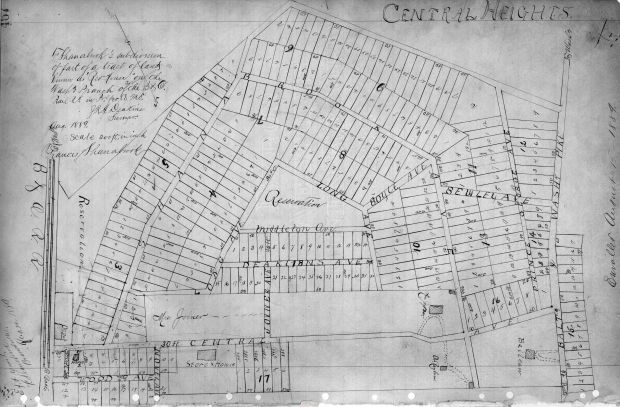
Shanabrook Central Heights plat dated August 1889. The B&O Depot is on the lower left.
Only a few months after platting the subdivision, Shanabrook sold it to a Washington real estate developer and President of the Lincoln National Bank, John A. Prescott in December 1889.20 Having purchased the subdivision, Prescott served as Treasurer of a group of investors that incorporated the Berwyn Land Improvement Company of Washington D.C. in January 1890.21 The Company’s board of directors included Frank Middleton and Ellis Spear (1834-1917), both of whom, you may recall, were partners in the D.C. law firm Spear, Middleton, Donaldson & Hall. General Spear, a former Commissioner of Patents and a friend of Middleton, became president of the Company. The new owners had the tract resurveyed and recorded under the name Berwyn in July 1890.22 The streets were renamed and improved, and new houses built. Then, in January 1891, John Prescott sold the Berwyn subdivision to Frank Middleton.23
Note that the use of Berwyn in Berwyn Land Improvement Company occurred prior to the laying of the corner stone of the future church in May1890 and the official naming of Berwyn Chapel in April 1891.24 This reverses the sequence of events as commonly told, that is to say the naming of the community followed the naming of the church. What to make of this? Does it mean the entire subdivision was named after the boy Berwyn? Maybe. It does appear that Frank Middleton was key to naming the subdivision, considering his role as a developer and as a leader of the church. Furthermore, the Middletons may well have had connections to Berwyn, PA as Frank’s father, Leander Middleton, was born in Lancaster County, Pennsylvania25 not too far from Berwyn.
The renaming of Charlton Heights had to wait until its incorporation in 1896, which followed the death of Benjamin Charlton in June 1894 and James Waugh in May 1895. Both men were instrumental in the creation of Charlton Heights. Waugh resided there until his passing and owned a large number of lots in the subdivision. It is unlikely Waugh, Charlton or Charlton’s nephew Edward Graves, who also owned a substantial chunk of the subdivision, would have considered a name change.
However, Charlton Heights’ reputation had taken a blow from the bankruptcy of the Charlton Heights Improvement Company in 1892 and subsequent lawsuits by disgruntled clients who had purchased property in the community based on promises of high-end amenities that never materialized.26 When the opportunity arose, residents changed the name of this place to Berwyn Heights. The B&O railroad station and post office followed suit27
Author: Kerstin Harper
1“History and Development of the City of College Park, Berwyn Heights, Greenbelt and Adjacent Area,” T. Raymond Burch, 1965. See also “The Berwyn News,” Vol. 18, Issue 10, December 2010, p.2; and “Berwyn Heights, The History of a Small Maryland Town,” Donald D. Skarda, 1976, p. 35.
2“Letter from Canon A. Pierce Middleton to Winfried Kelley, Maryland Secretary of State,” (shared with former Berwyn Heights Mayor Bill Armistead), 14 November 1991; and “Lengthy Illness Fatal to Lawyer,” The Evening Star, 13 March 1930, p. A-9.
3Then & Now: Berwyn Heights,” Ann Harris Davidson, Arcadia Publishing, 2007, p. 63. In a personal email, Ms. Davidson says that this piece of information came from the late Frances Keefauver-Hoyert, historian and long-time member of Berwyn Presbyterian Church.
4“History 1885-1958 Berwyn United Presbyterian Church,” attributed to Frances Keefauver-Hoyert by current Deacon of Berwyn Presbyterian Church Rex Powell and Church Historian Barbara Simmons.
5Burch, History and Development of the City of College Park, Chapter “Churches.”
6Burch, History and Development of the City of College Park, Chapter “Churches,” and College Park News, The Evening Star, 15 April 1901, p.15; and “Berwyn among the Beautiful Maryland Hills,” The Washington Times, 17 May 1903, p.5; and “Better Facilities for Getting in and out of Washington,” The Evening Star, 20 April 1901, p. 15.
7“Mortgagee’s Sale of a Fine Truck Farm in the 12 District of Baltimore County,” Baltimore County Union, 5 February 1882, p.2; and Baltimore County Land Records, Deed March 4, 1867 Francis & Ellen Shanabrook to George Ehrhardt, Book 52-365.
8Baltimore City Business Directories, 1868-1874.
9Boyle, Sarah E.; p. T 396, Enumeration District 101, Howard County, Maryland, Census Bureau, 10th Census of the United States, 1880.
10Martenet, Simon J. Martenet’s Map of Howard County, Maryland: drawn entirely from actual surveys. Baltimore: John Schofield, 1860. Retrieved from the Library of Congress, <www.loc.gov/item/2002624032/> .
11PGC Land Records, Deed 26 December 1874, Thomas Brundige, Trustee to Sarah Boyle, Book HB 9-575.
12PGC Land Records, Indenture 19 February 1896, Sarah Boyle to John Bewley, parts of Red House, Chews Folly & Rossburg tracts, Book HB 11-64.
13PGC Land Records, Lease 13 November 1876, Sarah Boyle to Francis Shanabrook, 120 acres, Book HB 12-486.
14PGC Land Records, Deed 9 October 1876, Sarah Boyle to Francis Shanabrook, Book ATB 1-602.
15PGC Land Records, Deed 13 January 1885, Sarah Boyle to Francis Shanabrook, Book 4-239.
16PGC Land Records, Deed 6 March 1886, Sarah Boyle to Frank Middleton (Shanabrook cosigner), Book 6-222.
17PGC Land Records, Central Heights plat, August 1889, Book 13-467.
18Burch, History and Development of the City of College Park, Chapter “Berwyn.”
19PGC Land Records, Deed 28 September1888, Francis Shanabrook to B&O RR, 40,000 square feet, Book 10-451.
20PGC Land Records, Deed 16 December 1889, Francis Shanabrook to John Prescott, Central Heights subdivision, Book 12-609; and “John A Prescott,” obituary, The Washington Times, 15 May 1919, p. 5.
21“To be Known as Berwyn,” Evening Star, 12 February 1890, p.8.
22 PGC Land Records, Plat Book BB-5 54.
23 PGC Land Records, Deed 5 January 1891, John A. Prescott to Frank L. Middleton, Book 17-361.
24 “History 1885-1958 Berwyn United Presbyterian Church,” Frances Keefauver-Hoyert.
25 Birth Record of Leander B. Middleton’s Daughter Annie V., Washington, D.C, Select Births & Christenings, 1830-1955.
26“Equity Case Files re: lawsuits against Charlton Heights Improvement Company, Charlton Heights Investment & Building Association,” Record Group 21, Entry 69, U.S. National Archives & Records Administration.
27 Record of Appointment of Postmasters, 1832- 1971; National Archives and Records Administration; Washington, D.C., Roll #: 56; Archive Publication #: M841.
Sportland for Sale Again
Berwyn Heights’ oldest home, dating to the 1790s, is on the market again. An open house is scheduled for Sunday, August 23, 2-4 p.m. It is listed for $349,000 with Long and Foster: https://www.longandfoster.com/homes-for-sale/5933-Natasha-Drive-Berwyn-Heights-MD-20740-303106966.
Sportland was in foreclosure in 2014 and was eventually purchased by an investor, who fixed it up and turned it into a rental property. It looks pretty nice from the curb, but needed a lot of work when the BHHC toured it in 2014.
BHHC members Debby Steele Snyder, Sharmila Bhatia and Kerstin Harper attended the open house and had the opportunity to speak with former Sportland owner Pat Brown. Pat was happy to share information about what the house used to look like when her family lived there, as well as rumors that continue to circulate: the house had tunnels serving as escape routes when it was an underground railroad safe house; a Civil War hospital and a distillery during prohibition.
-
- Sportland today. The older 1- story part of the house was built around 1790 by James Edmonston on his 522 acre tract called ‘Yarrow’. The addition was built by Ethan Allen Jones and his wife Laura between 1850-1863.
-
- Sportland ca. mid-20th century. The photo was taken by James Wilfong, a former President of the Prince George’s County Historical Society. His collection of photos of historic structures are held by the Historic Society and are available online at http://www.digitalmaryland.org.
-
- The 2 1/2 story addition of Sportland features a grand staircase in the side hall.
-

- Fireplace in one of two parlors. It has an original wooden mantel but the tile work probably dates from the 1960s.
-
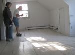
- A bedroom on the 3rd floor of the addition.
-

- The basement with field stone foundation.
-

- Former owner of Sportland, Pat Brown in what once was her bedroom. Pat was available during the open house on August 23, 2020 to answer questions about the property before it was transformed into a student rental.
-
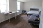
- This south-facing, former parlor was transformed into bedroom 1, one of 5 housing UMD students. The original fireplace has been covered with wallboard.
-
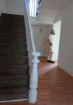
- The grand staircase after the 2015 renovation. The railings have been painted and the treads carpeted. The original pine board floors are still present under the new flooring.
-

- This sunny bedroom is located on the 3rd floor and overlooks the front yard.
-

- Pat Brown shows BHHC members Sharmila Bhatia and Kerstin Harper the unfinished basement under the old portion of the house. Pat confirmed rumors of a tunnel leading away from the south wall of the basement. There also is an access to a deeper room with a cistern that was probably used for cold storage of food.
-
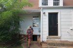
- Pat Brown and Sharmila Bhatia exit basement in the rear of the house.
The Crossing – Bypass

In 1942, the old Branchville Road that used to form the northern boundary of the Town of Berwyn Heights was reconstructed along a new alignment as Greenbelt Road. This included a new overpass across the B&O railroad tracks, making it possible to close the dangerous Berwyn grade crossing. When that crossing was barricaded, sometime in September or October 1942, it became necessary to redirect traffic bound for Route 1 via State Road 434. Route 434 connected Edmonston Road and Baltimore Avenue along La Belle Avenue (today Pontiac Street & 57th Avenue) and Waugh and Central Avenues (Berwyn Road).1
The Berwyn Heights Commissioners wanted to make an outlet from La Belle Avenue to Branchville Road along Huntley Avenue (58th Avenue). But there was a little problem: Huntley Avenue stopped at Newby Avenue (Tecumseh Street), now just a paper street between block 26 and 27. Traffic, including Capital Transit buses, would have had to zig and zag along Newby and Howell Avenues to reach Greenbelt Road and cut into the property of a prominent citizen of the Town.

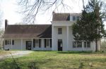
The Moyer-Cissell House today. Built by the Charlton Heights Improvement Company from a pattern book design in 1888.
Samuel Moyer, an attorney for the Department of the Interior, who served as Town Commissioner from 1926-1936 and President of the Berwyn Heights Volunteer Fire Department from 1924-1935,2 owned the now historic house at 8911 57th Avenue, as well as an adjoining orchard that lay in the path of the proposed road. He did not relish the taking of a slice of his land and suggested the Town purchase a right of way through unimproved properties in block 27, which belonged to the Berwyn Heights Company and Burch Realty.3
The Town Commissioners approached Berwyn Heights Company Vice President Margaret Benson and Burch Realty and they agreed to sell the Town the required land to make the new outlet.4 The State Roads Commission built the road, which was taken into service in 1945 as Route 251. In 1990, the State Highway Administration renovated these streets and transferred them to the Town.5
The extension of 58th Avenue to Greenbelt Road resulted in a re-subdivision of the properties in block 27 and their subsequent development by the Berwyn Heights Company.6 Some of these properties no longer conform to today’s zoning standards and require variances when improvements are made. As recently as October 2019, the Town Council held a hearing on a variance application for 8906 58th Avenue and granted an exception for lot size and frontage width to allow the owner to build a house on the property.7
1 “Berwyn Crossing,” Greenbelt Cooperator, 24 April 1942, p2.
2 Photo of Members of the BHVFD (President Samuel H. Moyer standing 3rd from right), Dedication Day, 30 December 1930, posted on BHVFD website https://bhvfd14.org.
3 Letter from Samuel Moyer to Ewing Gupton, Secretary & Treasurer, Berwyn Heights Town Commissioners, 15 November 1942.
4 Minutes of Meeting of the Berwyn Heights Town Commissioners, 17 December 1942.
5 Excerpt of Minutes regarding Construction of Route 251, Maryland State Roads Commission, 15 October 1946.
6 PGC Land Records, 1955 Re-subdivision of Lots 8-22, Block 27; Plat Book WWW 26-21
7 Minutes of Meeting of the Berwyn Heights Town Council, 7 October 1919.
The Crossing
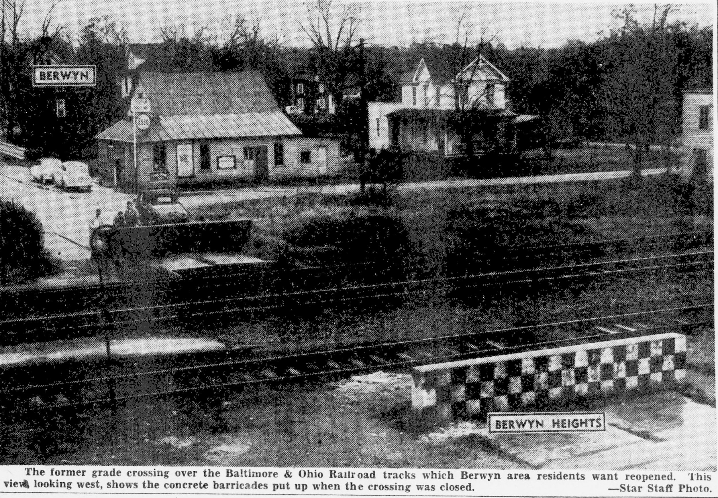
On April 18, 1942, two Berwyn Heights youths were killed when their truck was struck by an express train at the B&O crossing where today a pedestrian bridge connects Berwyn Heights and College Park. William Forrester, 16 and David Snydeman, 12 were returning from Keefauer’s grocery store and are believed to have stopped for a passing train. They resumed their trip after the train had passed but were hit by a B&O Capitol Limited going in the opposite direction.1
Ten year’s earlier, on July 21, 1931, a Miss Ethel Thomas of St. Ann’s Orphanage barely escaped with her life when her car stalled in the Berwyn crossing in the path of an oncoming express train. She was helped to safety by Edwin Yost and Andrew Mothershead of Berwyn Heights, who happened to be nearby. Two engineers on the train were not so lucky. Their clothes caught fire when the train rammed the car, and its exploding gas tank tossed a sheet of flames across the locomotive. The engineers jumped from the cab but did not survive. The fireman, also badly burnt, managed to bring the train to a stop.2
Grade crossings had become the scene of many accidents involving motorists in the first half of the 20th century, as the automobile was conquering America and highways started to crisscross the country. By 1930, there were over 220,000 unprotected grade crossings nationwide. Accidents at grade crossings peaked in the mid 1920s, killing nearly 2,100 persons and injuring another 6,200.3 Almost daily, newspapers reported deaths resulting from motorists colliding with trains.
In the D.C. area, collisions occurred with regularity at dozens of grade crossings. Congress passed a bill calling for the elimination of grade crossings in the City in 1927, but it took another 12 years to complete the task.4 Following one particularly deadly accident, in which 14 students returning from a science meet at the University of Maryland were killed when their school bus crashed into an express train at a Rockville grade crossing, public pressure mounted to eliminate them.5 The Evening Star, Washington’s newspaper of record had made it its mission to push for the elimination of grade crossings, and renewed its call to get rid of these ‘death traps’.6 But progress was slow because it required securing financing in the legislatures and from railways, and then relocating highways or building bridges and tunnels.
By 1939, the Berwyn crossing was one of only 12 unsecured grade crossings remaining in the greater Washington area and slated to be closed within a year. The State of Maryland had appropriated $150,000 for the State Roads Commission to build an overpass over the B&O tracks at Branchville Road.7 The reconstruction of Branchville Road (now Greenbelt Road) with the overpass was completed in the fall of 1942, a few months after the deadly accident.
The new safe route over the B&O tracks did not quite end the drama over the Berwyn crossing. The residents of Berwyn Heights and Berwyn chafed under the separation of their communities and resented having to detour over the Branchville Road to get their mail, go shopping and visit their church. Several of Berwyn’s shopkeepers 8 had homes in Berwyn Heights and would no doubt have preferred to keep the direct road open. Town Commissioners brought up the reopening of the crossing at monthly meetings but County Commissioner Edward ‘Ned’ Waters, residing at 8507 60th Avenue in Berwyn Heights, took the matter to new level.
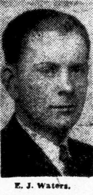 After being elected to the County Council in 1950, Waters organized public hearings and conferences with the B&O Railroad and the State Roads Commission to press for the crossing’s reopening. He claimed its closure was illegal because no prior public hearing had been held; and that the barricades themselves posed a risk to life and limb as cars crashed into them. He insisted a reopening was supported by the Town’s Commissioners, Volunteer Fire Departments, the College Park Businessman’s Association and “every man, woman and child in Berwyn and Berwyn Heights.”9
The B&O Railroad and the State Roads Commission were unmoved, noting that the Branchville Road overpass was funded in conformance with a larger national policy to eliminate grade crossings.10 Waters did not give up and prepared to take the matter to court. However, the County’s attorney refused to “file a spurious and improper court suit… when we [the County Commissioners] do not have a leg to stand on.”11 He resigned shortly after the disagreement and the effort to reopen the Berwyn crossing died. Eventually, the communities on either side of the tracks adjusted to the separation.
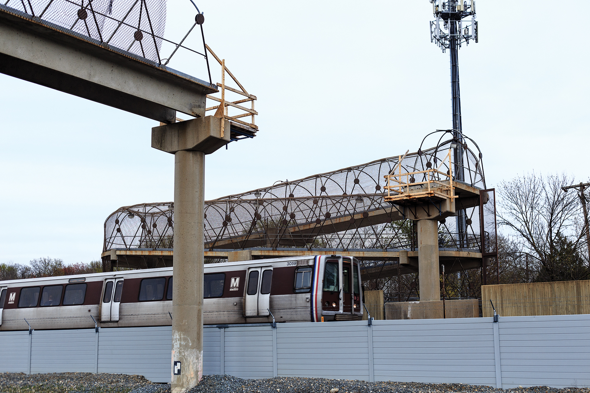 Nobody would seriously consider crossing those tracks today. There is a pedestrian bridge now with accessible ramps that spans 5 actively used tracks: 2 Metro Green Line tracks, a Metro test track all powered by electrified third rails, and 2 CSX tracks. Tall fences run along the tracks to keep people away. But the spot has not been without incident. On April 14, 2015, the pedestrian bridge was accidentally knocked down by a construction crane brought in by rail for building the test track. By a stroke of luck, no one was hurt. The bridge reopened a year later and has been open for business since.12 Go on up and have a look. A train might pass below you.
Author:
Kerstin Harper
Sources:
1 “Two Youths Killed When Train Hits Auto at Berwyn,” The Evening Star, 19 April 1942, page A-1; and “Berwyn Crossing,” Greenbelt Cooperator, 24 April 1942, page 2.
2 “Train-Auto Crash Inquest to Probe Two Men’s Deaths,” The Evening Star, 22 July 1931, page 1.
3 Accident bulletin, Interstate Commerce Commission, Bureau of Statistics. Washington: U.S. G.P.O., 1942 , Page 12.
4 “Elimination of 3 Major Crossings in D.C. Area Planned,” The Sunday Star, 24 September 1939, page B-6.
5 “Fourteen Deaths in School Bus Probed,” The Evening Star, 12 April 1935, pages A-1, A-4, A-5, A-6, A-7, A-10; and “Acclaim President’s Project to End Crossing Death Traps,” The Evening Star, 26 April 1935, page A-10.
6 “50 Years Ago,” The Evening Star, 5 December 1948, page C-4.
7 “Elimination of Three Major Crossings in D.C. Area Planned,” The Sunday Star, 24 September 1939, page B-6.
8 Charles Mayo & Lillian Attick – Barbershop; Charles, Jr. & Bessie Attick – Barbershop; John & Josephine Burch – Realty Agency.
9 “Berwyn Fights to Reopen Berwyn Road Crossing,” The Evening Star, 10 December 1951, page B-1.
10 “County Heads to Ask Order to Open Berwyn Rail Crossing,” The Evening Star, 2 August, 1951, page A-18.
11 “County Attorney Offers to Resign Following Verbal Tilt,” The Evening Star, 5 December 1951, page C-1
12 “A Year After its Collapse, Contractors will Replace Pedestrian Bridge,” The Diamondback, 14 April 2016
Untamed Indian Creek
 Many people commented on a set of photos of Berwyn Heights from the 1960s we published here, and reposted on the BHHC facebook page. They helped us identify the first photo on the left as the untamed Indian Creek prior to 1972. Mike Hayden and Angelo Ohwell, who grew up in Berwyn Heights during this period, said this is what Indian Creek looked like from Berwyn Road bridge when facing Greenbelt Road.
Ohwell said “Indian Creek would change [its course] as it flooded so much, leaving it to meander around a lot.” The photo does appear to show signs of a recent flood, with sand and flattened grass on the banks.
Mike Hayden said the buildings on the right belonged to the Peacock and/ or the Smith families who lived there until 1972. They sold their properties to the Maryland National Park & Planning Commission (M-NCPPC)i which then built a paddle tennis court in that location, and further north a T-ball field and playground.
But first the Army Corps of Engineers set to work widening and straightening Indian Creek to control flooding starting in April 1973. The channelization project was made a priority after Hurricane Agnes struck the Mid-Atlantic region in June 1972 and caused severe flooding throughout Maryland and in Berwyn Heights. In the aftermath of Agnes, the Town assisted flood victims by providing pumps, jacks, clean-up trucks and maintenance personnel. The fire department, women’s auxiliary, and police pitched in, while the Corps of Enineers dredged and cleaned the creek.ii
Other readers, including Fred Flaherty and Debbie Pitts, shared memories about fishing in the creek, which apparently continued after the widening. Note the boy with his rod in the lower right of the second photo. Mary Lou Milstead and Bettie Prosise in a BHHC oral history recording confirm that anglers often caught catfish and that the river valley served as a great playground.
In the second photo, Greenbelt Road can be seen in the distance and behind it a gravel mountain of the Alfred H. Smith gravel mine. Many old time residents were none too happy with Al Smith because his gravel washing operation ruined Indian Creek, filling it with waste water and silt. Ruth (Sauer) Ellsworth, who grew up in Berwyn Heights during the 1940s, recalls that the creek once was so deep it looked dark green and bottomless from the bridge above.iii
Former Town Commissioner Charles Worden, in one of a series of Bulletin articles about Berwyn Heights in the 1920s and 1930s, said that the pool at the bridge was perhaps 10′ deep and quite suitable for swimming. People then caught bass and pickerel in the creek and trapped muskrat, too.iv
i PGC Land Records: Deed 1972May12 Clay & Exie Peacock, lots 18-19 block 3, Book 4072-521; and Deed 1972Aug 2, Willard & Rita Smith to M-NCPPC, lots 20-21 block 3, Book 4116-873
ii Berwyn Heights Bulletins, 1972-1973.
iii Sauer Ellsworth, Ruth. Ruatan Street. Crimson Atlelier, Inc, New Hope, PA, 2005.
iv Worden, Charles. Berwyn Heights Bulletin, September 1972, p.7.
Berwyn Heights in the early 1960s
The Historical Committee recently received a set of photos of Berwyn Heights dating back to the early 1960s. The photos were taken by Meyer Keilsohn, a former resident of Pontiac Street. Neighbor Kathy Richardson rescued them from the roadside after a cleanout of the house. Some of Keilsohn’s photos have captions reading “Berwyn Heights” and the year the photo was taken, with years ranging between 1959 and 1965.
During this period major changes occurred in and around Berwyn Heights. In town, new subdivisions were platted and many new homes built. Nearby, Beltway Plaza opened in October 1963 and construction of the adjoining Springhill Lake Apartments was about to start. The Baltimore Washington Parkway, planned as an alternative to US Route 1 in the 1920s, had been completed in 1954. Route 201/ Kenilworth Avenue between Riverdale and Greenbelt had opened in 1958; and the first sections of the Capital Beltway were finished in 1961. Keilsohn’s photos capture that moment in time when the remaining empty land in and around Berwyn Heights was being filled in.
-

- 1964: View from Meyer Keilsohn’s home at the top of Pontiac Street. In the distance is the recently opened Beltway Plaza shopping center. In 1964, S. Klein’s Department Store dominated the mall. Behind the mall is as yet undeveloped land where the Springhill Lake Apartments were about to be built.
-

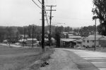
- Ca 1960: Looking west down Pontiac Street. The median strip indicates a divided highway. Pontiac Street was then still part of MD Route 434. It connected Edmonston Road with Baltimore Avenue before the B&O railroad crossing was closed in 1942. SHA renovated Pontiac Street and transferred it to the Town in 1990.
-
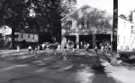
- 1965: Coaching baseball at the Berwyn Heights Elementary ball field. The batting cage appears to have been right next to Quebec Street. The house with ornate pillars seen behind it at the time belonged to James and Harriette Houser. James served on the Town Council from 1968-1972.
-
- 1961: Majorettes practicing in front of the BHVFD fire house on 57th Avenue which now serves as a Senior Center and events venue. The house on the left is a Sear’s bungalow built by John Yost in 1925. Yost was Chief of the BHVFD in the 1930s.
-

- Ca 1960: Indian Creek at 56th Avenue playground. In the distance, Greenbelt Road bridge and behind it a gravel mountain at the A. H. Smith gravel mine. Notice the boy fishing in lower right corner.
-
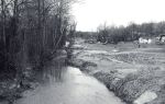
- Ca 1960: Somewhere along Indian Creek with the Berwyn Heights hillside (presumably) on right. Too narrow for the main channel of Indian Creek, it is perhaps a side arm of the once braided stream, or a tributary. Sand and flattened grass on the banks could indicate a recent flood.
-
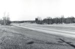
- 1959: The just opened Kenilworth Avenue is nearly empty of cars. The Pontiac Street intersection is on the left, marked by traffic signs and a passing car. Opposite a road not yet leading to Westchester Park.
-
- 1965: Photo of Edmonston Road taken near the intersection with Berwyn Road. The absence of trees and scrub in the strip between Edmonston Road and the new Kenilworth Avenue affords a clear view of the new the College Knolls subdivision.
-
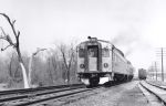
- 1961: Before the Metro, commuter trains served Berwyn Heights. The Berwyn Heights “station” and telegraph poles are on the right side of the tracks.
BH Company Centennial Recap

Nearly forty guests attended our 100th Anniversary of the founding of the Berwyn Heights Company. Lively discussion about the Company and Berwyn Heights history started even before the event with the hoisting of two large old maps and placing of exhibits during morning setup, and continued on a larger scale at the reception.
Once everyone had sampled our choice buffet and drinks, BHHC chair Richard Ahrens welcomed those present and unveiled the historic marker. Former chair Dave Williams made time to create the layout and fabricate the mockup. Thanks Dave.
For the presentation, we were happy to have Bruce Tobin with us, who supplied interesting details about the Company’s CEOs, his grandparents Clarence and Helen Benson, his uncle William Benson and his parents Mildred and Robert Tobin. Bruce also brought the original BH Company Minute Book, which got this whole celebration started.
The slideshow would not have happened if BHHC vice chair Sharmila Bhatia had not proposed it. Great idea, but a lot of work. The slideshow itself was based on many photos and documents collected by James Benson on his ancestry.com account, which he graciously opened to us. Unfortunately, Jim was not able to join us from his home on the west coast, but he may like to see the product. And others might, too. Please click image to view.

Berwyn Heights Company Centennial
 Please join us for our celebration of the 100th Anniversary of the Berwyn Heights Company. Find out how this community-based real estate company shaped the development of Berwyn Heights between 1919 and 1975. We will be joined by descendants of the Benson family who ran the Company for most of its existence.
2:00 pm
Meet and greet with Benson family descendants
2:30 pm
Welcome by BHHC Chair
2:35 pm
Unveiling of Historic Marker
2:40 pm
Slide show on Berwyn Heights Company.
3:30 pm
Discussion
4:00 pm
Optional 10-minute walk to former Benson House.
Wine and hors-d’œuvres are served for the duration.
The Behnke’s is History
 After 89 years, the gates of The Behnke’s Nursery are shuttered. Many people in Berwyn Heights and this corner of Prince George’s County have Behnke plants in their gardens and will miss having this horticultural oasis nearby. The nursery not only had a seemingly endless variety of flowers, trees and shrubs, but also offered gardening workshops, put on an Oktoberfest and each December opened a lavish Christmas shop.
In May, Stephanie Fleming, Vice President of The Behnke’s and grand-daughter of the business founders Albert and Rose Behnke, told the story of the nursery and the family who ran it. The presentation was hosted by the Greenbelt Museum.
PG History for $50 Please
Come Out and Play – Friday, April 5, 6:30 pm
The Historical Committee and Recreation Council will bring back the popular Team Trivia Night. The focus will be expanded from Berwyn Heights to include Prince George’s County trivia. Topics will vary – from geography to sports to science – but the spotlight is on History.
It’s free to play. Teams of up to six people compete for a first place cash prize of $50 and a second place prize of $20 in Domino’s Gift Cards. Drinks and snacks will be available.
Contact Jodie Kulpa-Eddy at (301) 345-1516 or email mdmarmot@yahoo.com to register your team name and number of team players. Singles are welcome. Let us know if you’d like us to find you a team. Everyone is invited to come and watch, though it’s more fun to play!
