Untamed Indian Creek
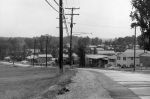
 Many people commented on a set of photos of Berwyn Heights from the 1960s we published here, and reposted on the BHHC facebook page. They helped us identify the first photo on the left as the untamed Indian Creek prior to 1972. Mike Hayden and Angelo Ohwell, who grew up in Berwyn Heights during this period, said this is what Indian Creek looked like from Berwyn Road bridge when facing Greenbelt Road.
Ohwell said “Indian Creek would change [its course] as it flooded so much, leaving it to meander around a lot.” The photo does appear to show signs of a recent flood, with sand and flattened grass on the banks.
Mike Hayden said the buildings on the right belonged to the Peacock and/ or the Smith families who lived there until 1972. They sold their properties to the Maryland National Park & Planning Commission (M-NCPPC)i which then built a paddle tennis court in that location, and further north a T-ball field and playground.
But first the Army Corps of Engineers set to work widening and straightening Indian Creek to control flooding starting in April 1973. The channelization project was made a priority after Hurricane Agnes struck the Mid-Atlantic region in June 1972 and caused severe flooding throughout Maryland and in Berwyn Heights. In the aftermath of Agnes, the Town assisted flood victims by providing pumps, jacks, clean-up trucks and maintenance personnel. The fire department, women’s auxiliary, and police pitched in, while the Corps of Enineers dredged and cleaned the creek.ii
Other readers, including Fred Flaherty and Debbie Pitts, shared memories about fishing in the creek, which apparently continued after the widening. Note the boy with his rod in the lower right of the second photo. Mary Lou Milstead and Bettie Prosise in a BHHC oral history recording confirm that anglers often caught catfish and that the river valley served as a great playground.
In the second photo, Greenbelt Road can be seen in the distance and behind it a gravel mountain of the Alfred H. Smith gravel mine. Many old time residents were none too happy with Al Smith because his gravel washing operation ruined Indian Creek, filling it with waste water and silt. Ruth (Sauer) Ellsworth, who grew up in Berwyn Heights during the 1940s, recalls that the creek once was so deep it looked dark green and bottomless from the bridge above.iii
Former Town Commissioner Charles Worden, in one of a series of Bulletin articles about Berwyn Heights in the 1920s and 1930s, said that the pool at the bridge was perhaps 10′ deep and quite suitable for swimming. People then caught bass and pickerel in the creek and trapped muskrat, too.iv
i PGC Land Records: Deed 1972May12 Clay & Exie Peacock, lots 18-19 block 3, Book 4072-521; and Deed 1972Aug 2, Willard & Rita Smith to M-NCPPC, lots 20-21 block 3, Book 4116-873
ii Berwyn Heights Bulletins, 1972-1973.
iii Sauer Ellsworth, Ruth. Ruatan Street. Crimson Atlelier, Inc, New Hope, PA, 2005.
iv Worden, Charles. Berwyn Heights Bulletin, September 1972, p.7.
Berwyn Heights in the early 1960s
The Historical Committee recently received a set of photos of Berwyn Heights dating back to the early 1960s. The photos were taken by Meyer Keilsohn, a former resident of Pontiac Street. Neighbor Kathy Richardson rescued them from the roadside after a cleanout of the house. Some of Keilsohn’s photos have captions reading “Berwyn Heights” and the year the photo was taken, with years ranging between 1959 and 1965.
During this period major changes occurred in and around Berwyn Heights. In town, new subdivisions were platted and many new homes built. Nearby, Beltway Plaza opened in October 1963 and construction of the adjoining Springhill Lake Apartments was about to start. The Baltimore Washington Parkway, planned as an alternative to US Route 1 in the 1920s, had been completed in 1954. Route 201/ Kenilworth Avenue between Riverdale and Greenbelt had opened in 1958; and the first sections of the Capital Beltway were finished in 1961. Keilsohn’s photos capture that moment in time when the remaining empty land in and around Berwyn Heights was being filled in.
-

- 1964: View from Meyer Keilsohn’s home at the top of Pontiac Street. In the distance is the recently opened Beltway Plaza shopping center. In 1964, S. Klein’s Department Store dominated the mall. Behind the mall is as yet undeveloped land where the Springhill Lake Apartments were about to be built.
-

- Ca 1960: Looking west down Pontiac Street. The median strip indicates a divided highway. Pontiac Street was then still part of MD Route 434. It connected Edmonston Road with Baltimore Avenue before the B&O railroad crossing was closed in 1942. SHA renovated Pontiac Street and transferred it to the Town in 1990.
-
- 1965: Coaching baseball at the Berwyn Heights Elementary ball field. The batting cage appears to have been right next to Quebec Street. The house with ornate pillars seen behind it at the time belonged to James and Harriette Houser. James served on the Town Council from 1968-1972.
-
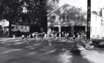
- 1961: Majorettes practicing in front of the BHVFD fire house on 57th Avenue which now serves as a Senior Center and events venue. The house on the left is a Sear’s bungalow built by John Yost in 1925. Yost was Chief of the BHVFD in the 1930s.
-

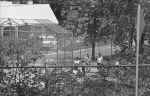
- Ca 1960: Indian Creek at 56th Avenue playground. In the distance, Greenbelt Road bridge and behind it a gravel mountain at the A. H. Smith gravel mine. Notice the boy fishing in lower right corner.
-
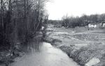
- Ca 1960: Somewhere along Indian Creek with the Berwyn Heights hillside (presumably) on right. Too narrow for the main channel of Indian Creek, it is perhaps a side arm of the once braided stream, or a tributary. Sand and flattened grass on the banks could indicate a recent flood.
-
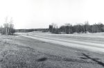
- 1959: The just opened Kenilworth Avenue is nearly empty of cars. The Pontiac Street intersection is on the left, marked by traffic signs and a passing car. Opposite a road not yet leading to Westchester Park.
-
- 1965: Photo of Edmonston Road taken near the intersection with Berwyn Road. The absence of trees and scrub in the strip between Edmonston Road and the new Kenilworth Avenue affords a clear view of the new the College Knolls subdivision.
-
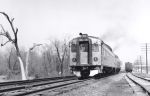
- 1961: Before the Metro, commuter trains served Berwyn Heights. The Berwyn Heights “station” and telegraph poles are on the right side of the tracks.
