The Historical Committee recently received a set of photos of Berwyn Heights dating back to the early 1960s. The photos were taken by Meyer Keilsohn, a former resident of Pontiac Street. Neighbor Kathy Richardson rescued them from the roadside after a cleanout of the house. Some of Keilsohn’s photos have captions reading “Berwyn Heights” and the year the photo was taken, with years ranging between 1959 and 1965.
During this period major changes occurred in and around Berwyn Heights. In town, new subdivisions were platted and many new homes built. Nearby, Beltway Plaza opened in October 1963 and construction of the adjoining Springhill Lake Apartments was about to start. The Baltimore Washington Parkway, planned as an alternative to US Route 1 in the 1920s, had been completed in 1954. Route 201/ Kenilworth Avenue between Riverdale and Greenbelt had opened in 1958; and the first sections of the Capital Beltway were finished in 1961. Keilsohn’s photos capture that moment in time when the remaining empty land in and around Berwyn Heights was being filled in.
-

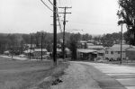
- 1964: View from Meyer Keilsohn’s home at the top of Pontiac Street. In the distance is the recently opened Beltway Plaza shopping center. In 1964, S. Klein’s Department Store dominated the mall. Behind the mall is as yet undeveloped land where the Springhill Lake Apartments were about to be built.
-

- Ca 1960: Looking west down Pontiac Street. The median strip indicates a divided highway. Pontiac Street was then still part of MD Route 434. It connected Edmonston Road with Baltimore Avenue before the B&O railroad crossing was closed in 1942. SHA renovated Pontiac Street and transferred it to the Town in 1990.
-
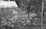
- 1965: Coaching baseball at the Berwyn Heights Elementary ball field. The batting cage appears to have been right next to Quebec Street. The house with ornate pillars seen behind it at the time belonged to James and Harriette Houser. James served on the Town Council from 1968-1972.
-
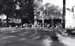
- 1961: Majorettes practicing in front of the BHVFD fire house on 57th Avenue which now serves as a Senior Center and events venue. The house on the left is a Sear’s bungalow built by John Yost in 1925. Yost was Chief of the BHVFD in the 1930s.
-

- Ca 1960: Indian Creek at 56th Avenue playground. In the distance, Greenbelt Road bridge and behind it a gravel mountain at the A. H. Smith gravel mine. Notice the boy fishing in lower right corner.
-
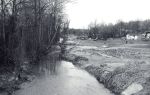
- Ca 1960: Somewhere along Indian Creek with the Berwyn Heights hillside (presumably) on right. Too narrow for the main channel of Indian Creek, it is perhaps a side arm of the once braided stream, or a tributary. Sand and flattened grass on the banks could indicate a recent flood.
-
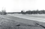
- 1959: The just opened Kenilworth Avenue is nearly empty of cars. The Pontiac Street intersection is on the left, marked by traffic signs and a passing car. Opposite a road not yet leading to Westchester Park.
-
- 1965: Photo of Edmonston Road taken near the intersection with Berwyn Road. The absence of trees and scrub in the strip between Edmonston Road and the new Kenilworth Avenue affords a clear view of the new the College Knolls subdivision.
-
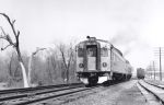
- 1961: Before the Metro, commuter trains served Berwyn Heights. The Berwyn Heights “station” and telegraph poles are on the right side of the tracks.

The reference to S Kiens dominating the mall is in correct. There was no mall at that time..only a short stop shopping center on the west side of that property, and the S Kleins department store on the east side .. it remained that like that for many years.
“1965: Coaching Baseball at the BHES Ball Field”. Yes, home plate for baseball was at the corner of Quebec Street and 63rd Ave. The softball home plate was at 63rd and Pontiac St. That is a 1960 Buick station wagon in our (Houser) driveway. I put it in gear (no key reqd) and coasted it into a tree at about age 3.5 y.o. The Buick is parked in front of an addition (one of two) that was a carport. Mom and dad moved into the house in 1954. Paid about $13,500 for the rambler-style house. Karl Houser, 2020